Mushroom Drops
Region: Boynton Canyon
Total Distance: 5 miles +
Total Elevation Gain: Up to 1,200’ +
Difficulty: Moderate
ACA: 3All
Duration: 4-6 hours
Longest Rappel: 200’
Rope: 2 x 200’
Anchor Materials: 50’ of webbing + 4 rapides
Parking: Boynton Canyon TH
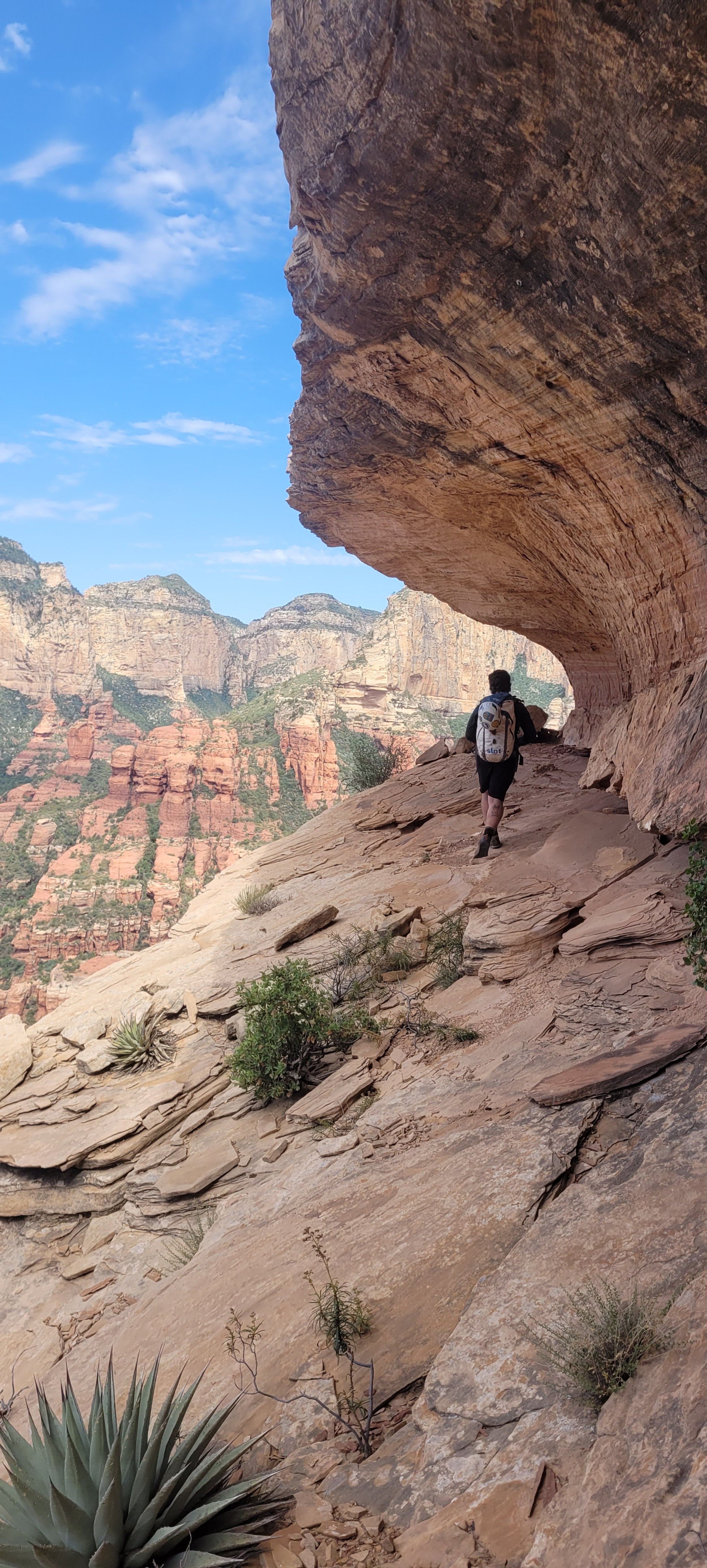
Overview: A short and scenic moderate adventure through an ancient watercourse. Mushroom Drops starts with an adventurous approach to the iconic Mushroom Rock. A clean nut somewhat meandering approach will challenge your route finding skills. If you are on the right path bushwhacking is minimal. Summit baggers will enjoy the nearby “Sky Island” for 5-star panoramic views of Boynton and Long Canyons. The rappel sequence offers two large free hanging rappels and a unique waterway. The route is one of my personal favorites, and in my opinion “the juice is certainly worth the squeeze”.
Approach(2 hours): Starting at Boynton Canyon TH, hike 1.5 miles until you pass the resort on your left and Kings cave on your right. Just after passing the large old stump on your left, and just before the trail bends left again, locate the prominent turn off on the right side. Follow a well worn trail across a main wash, through a manzanita field, and up to the top of a small ridgeline. Once atop the small ridge follow the trail right staying above the drainage on durable rock. You will know you are still on track when you are hugging a two-tone wave shaped wall on your on your right. Continue up through a jurassic manzanita forest, home to some of the largest living manzanita in Boynton Canyon. Some minor scrambling will lead you to the top of the next bench. Head left from here across the sloping sandstone slab into the next gully around the corner on the right. From this section Mushroom Rock will soon come into sight floating overhead. You can by pass R1 here if desired and traverse over to the second rappel. For full value visit mushroom rock and take the short detour to sky island before dropping into the technical section. Follow the track and faint social trail East up to the iconic “Mushroom Rock”. After arriving at mushroom rock continue a short distance up the red rock slab to a patch of bushy terrain. From here head West or to the left to where the white rock and red rock meet. Traverse this line a short distance to the bushy drainage above R1. Down-hike the shallow drainage to the R1 anchor where there is just enough room to gear up if you haven’t already.
Descent (2 hours): 3 to 4 rappels up to 200’ (depending on where you start) R1 can be bypassed if you decide to skip visitng mushroom drop, you can traverse over to the R2 anchor. This cliffaneering style route follows a faint watercourse through an ancient dam and finishes with a large free hanging rappel.
R1: 150’ over hung, mostly free hanging, RDC off large tree in the center of the watercourse.
***Continue RDC to slick rock water course.
R2: 60’ off a bolted anchor RDC in the watercourse.
*** Continue RDC in watercourse bypassing the next drop with an easy downclimb on the left side. You will pass the remnants on an ancient damn on your left side.
R3: 40' off tree LDC on edge. This rappel has an awkward and exposed start off a small pine tree. Use extra caution while rigging.
R4: 200' off tree. Webbing is extended near the lip. Mostly free hanging with a funky start. Trail rope to the edge and drop straight down, watch for potential hikers below. An awkward start over an abrupt edge quickly drops into a 200’ free hanging rappel. You will likely need to pull off some ninja skills to avoid some the bushes below. Pull from LDC & back to avoid abrasion. It is recommended to extend the pull side for easier retrieval.
Exit (less than 1 hour): Follow the drainage a short distance to the main drainage eventually turning left and heading back towards the main trail. The main wash parallels the trail and can be exited on the right side. Return the way you came if not linking up a nearby route.
Coordinates:
Turnoff: 34.92531, -111.85817
Mushroom Rock: 34.92950, -111.85233
Sky Island: 34.93224, -111.85565
Preservation: Please respect sensitive terrain and archaeological sites along your journey.
Flow: Mushrooms drops is an excellent option during wet conditions. This route can has a well-worn approach, low risk of flash flood potential, and comes to life with a little bit of flow.
Route Established By: Lars Romig, Laura Stewart, Eric & Kegn Moorcroft