Video Courtesy of: Jerry Arizona
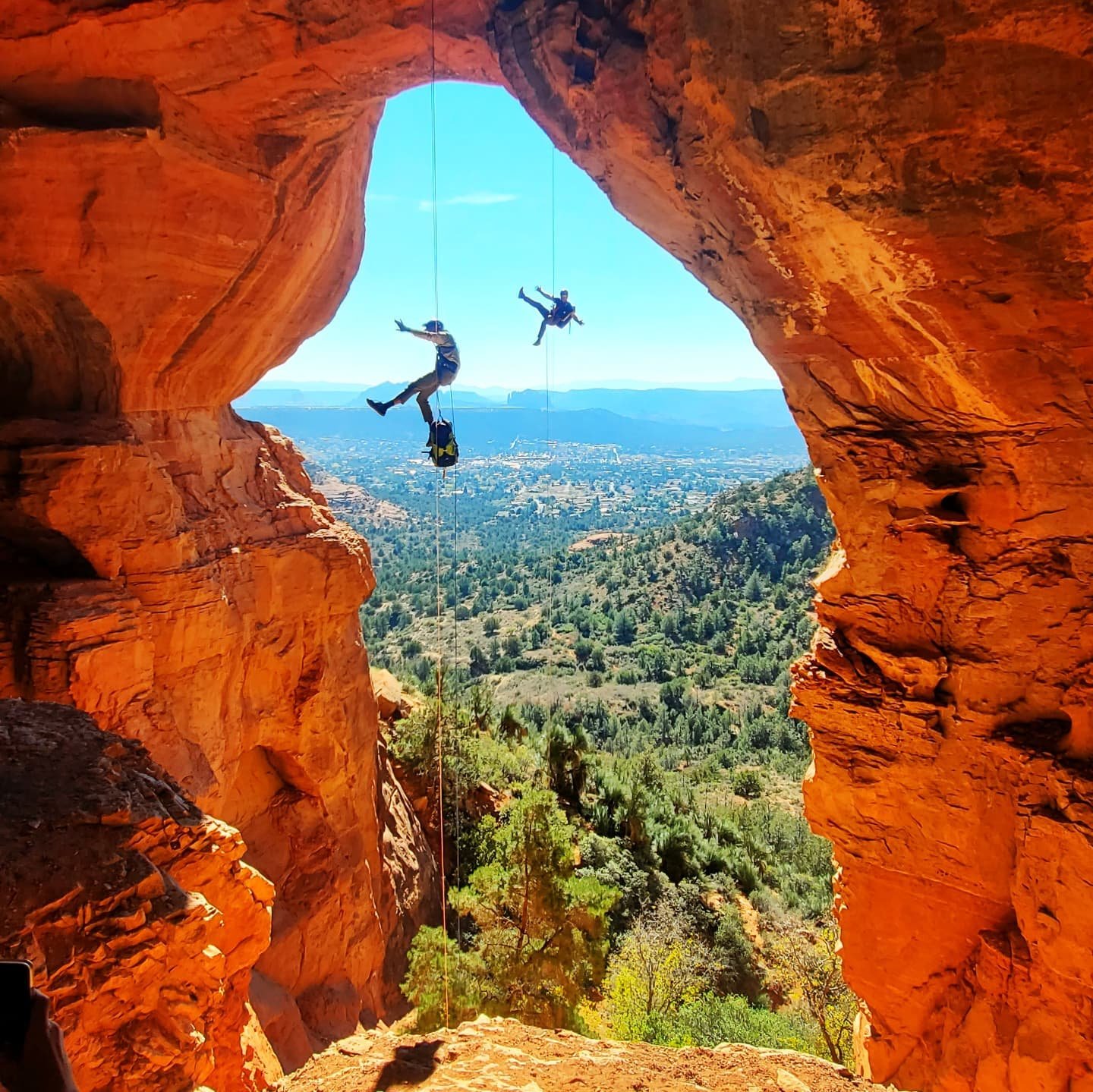
Spyhole
Region: Sugarloaf Trailhead
Total Distance: 3+ miles
Total Elevation Gan: ~1,200’
Difficulty: Moderate
ACA: 3Alll
Duration: 4-6 Hours
Longest Rappel: 170’
Rope: 1 x 200’ + 1 x 200’ Pull Cord
Anchor Materials: 30’ of webbing + 3 rapides
Parking: Park at Sugarloaf TH. The parking lot is rather small and will fill up early. Alternative parking may be available on Kinsey Ct.
Overview: A short but steep off trail approach up loose terrain, Spyhole descends the watercourse above the popular keyhole cave. For those craving a short and memorable technical adventure close to town this one fits the bill. The keyhole cave is visited daily and has become a bucket list hiking destination. Extra caution and consideration for the safety of other adventurers should be taken. The highlight of this route is the Spyhole, a deep hole at the base of R2 that opens up into the keyhole cave. Spyhole is rated moderate because it is short but challenging, with extra risks of loose rock and hikers below.
Challenging approach
Bucket list Sedona cave
Unique re-belay in the Spyhole or Large free hanging rappel
Approach(1.5+ hours): Helmets Recommended
From the Sugarloaf trailhead take the teacup trail.3 miles to the intersection with Thunder Mountain trail, Continue straight at the junction onto a prominent social trail that follows the left side of the drainage. Soon the keyhole cave will come into view and you will end up winding your way through the main drainage below. Stay in the drainage until the large cliff face on the right drops and dissolves into a bushy ridgeline. Helmets are recommended for the steep and loose hillside on the next section. Once atop the ridge it’s smooth sailing as you head East, traversing low-angle terrain. Down hike a short distance to a large pine and Coconino slab. Gear up and snack down here as you have arrived at R1.
Coordinates:
Turnoff: 34.8875, -111.8039
Descent (1-2 hours): The short technical section starts down poor quality rock, but quickly cleans up. There are two options for the last rappel.
R1: 170’ to red rock slab. Recommended to set rappel side RDC and rappel down crack. Setting the pull side LDC. High potential of Rockfall, trail the rope. Clipping into R2 bolts RDC is a safe place to avoid rock fall during descent and rope pull.
R2: 100’ from bolts RDC.
R3: there are 2 options for the final rappel 100’ or 160’
Option 1- Spyhole – at the base of rappel 2 you will land very close to the spyhole and it can be easy to pass, Locate the the spyhole and use fixed line or anchor from tree above the spyhole for 15’ rappel into the hole, landing on a one person ledge with fixed bolts. This rappel is just under 100’ from bolts. Head lamp is recommended for rigging inside the hole. Trailing rope through the hole or lowering the rope slowly is recommended for the safety of hikers below. Hanging your pack will help prevent rockfall from within the Spyhole.
Or
Option 2- Original anchor- Approximately 30’ past the spyhole on the right side is a set of bolts and chains. 160’ from the bolts in a mostly free hanging rappel with an easy but exposed start.
The cave interior is accessed on the Left side and is made possible by a short but steep scramble with positive hand and foot holds.
Exit (<1 hour):
After the last rappel, take braided social trails staying high and left of the drainage. Soon you will connect with the main drainage and the trail that you came in on. Follow main wash and social trails back to the car park.
Local tip: Go early!
Safety: Hikers are always present. Rock fall danger is real. Be mindful and safe when retrieving the rope.
Route Established By: Lars Romig & Laura Stewart
Spyhole Rappel Discovered By: Kevin Iosue & Bogan Lawrence